Route
| SATURDAY | ||||||
| Please note that the Holiday Home is back in use this year
Please note also that the Millbank checkpoint has been moved to the old mill site at Kebroyd |
||||||
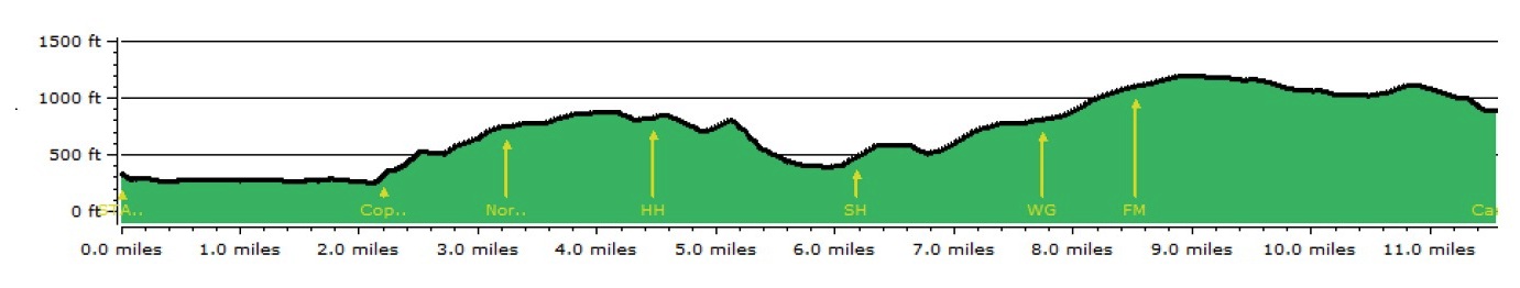
| Checkpoint | Miles | Grid Ref | Name | Location | Chop Time | |
| START | 0 | SE 059 237 | Base | St Paul’s Church | ||
| 2 | 2.2 | SE 085 223 | Copley | St Stephen’s Church | ||
| 3 | 3.2 | SE 069 220 | Norland | Clough Moor Bridge | ||
| 4 | 4.5 | SE 053 216 | Half Kirk | Holiday Home | Navigation Exercise 1 Start | |
| 5 | 6.7 | SE 042 213 | Kebroyd | Site of old mill | Navigation Exercise 1 Finish | |
| 6 | 7.7 | SE 022 207 | Water Green | In front of the big garage | 16:00 | |
| 7 | 8.5 | SE 013 212 | Flints Moor | Track Junction | Navigation Exercise 2 Start | |
| FINISH | 11.6 | SE 025 244 | Camp Site | Old Crib | Navigation Exercise 2 Finish | |
 |
||||||
| SUNDAY | ||||||
| START | 0 | SE 025 244 | Camp Site | Old Crib | ||
| 2 | 1.5 | SE 026 260 | Brearley | Brearley Lane | ||
| 3 | 1.9 | SE 027 264 | Midgley | Footpath entrance at the edge of the moor | ||
| 4 | 2.8 | SE 021 277 | Crow Hill Nook | Boundary Stone | ||
| 5 | 3.8 | SE 036 279 | Jerusalem Farm | Wade Bridge | 13:00 | |
| 6 | 4.8 | SE 046 269 | Stocks Lane | by Trough Farm | ||
| 7 | 6.5 | SE 057 248 | Warley Town | Playground Car Park | 14:45 | |
| FINISH | 7.4 | SE 059 237 | Base | St Paul’s Church | ||
 |
||||||
Route Maps
Please note that this is the recommended route and participants are free to choose the route that suits them, providing that all checkpoints are visited in the correct order.
The maps below are in PDF format and are large files (7MB) but can be scaled up to 400%
Brow Hike 2024 Day 1
Brow Hike 2024 Day 2
Some basic statistics
| DAY | DISTANCE | ALTITUDE GAIN | ALTITUDE LOSS |
| SATURDAY | 11.6 miles | 1950 feet (600m) | 1400 feet (430m) |
| SUNDAY | 7.4 miles | 1600 feet (490m) | 2160 feet (660m) |